The discovery of a map made by a Native American is reshaping thinking about the Lewis & Clark expedition
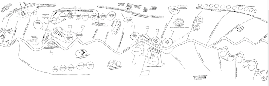
An important historical map drawn by a Native American leader for renowned American expedition leaders Meriwether Lewis and William Clark was recently discovered in the Bibliotheque Nationale de France.
“Monumental doesn’t fully cover the importance of this discovery,” says historian Clay Jenkinson. “This is easily the best-preserved of the Native American maps drawn for Lewis and Clark, and represents the most important discovery in the Lewis and Clark world since 55 letters by William Clark were discovered in a Louisville attic in the 1980s.”
Discovered by a University of New Mexico graduate student who was working on Native American cartography, the map was drawn by an Arikara leader named Too Né, whom Lewis and Clark met on today’s North Dakota-South Dakota border on October 8, 1804. It came to the attention of the Lewis and Clark world in 2017. This discovery is the central feature of the May issue of We Proceeded On, the peer-reviewed quarterly of the Lewis and Clark Expedition.
“This map deepens our understanding of how dependent Lewis and Clark were on Native American geographers,” says Jenkinson. “We tend to think that they were traveling blind into terra incognita. That is simply not true. Too Né’s map lifts the expedition’s encounter with the Arikara to new prominence, and it proves that individuals like Too Né were as important to the success of the expedition as, say, Sacagawea.”
The map was drawn by Too Né sometime in 1805 or early 1806, perhaps in St. Louis or Washington, DC. Too Né traveled with the Lewis and Clark expedition from the Arikara villages on the Grand River to the Mandan and Hidatsa villages on the Knife River between October 12-November 10, 1804. He joined the expedition temporarily to try to negotiate a peace between the Arikara and the Mandan, who had been in a state of hostility for several years. He was later persuaded by Lewis and Clark to visit the “Great Father” Thomas Jefferson in the national capital. Unfortunately, Too Né died in Washington on April 6, 1806, of natural causes.
We Proceeded On (WPO) is the journal of the Lewis and Clark Trail Heritage Foundation, headquartered in Great Falls, Montana. The May issue of WPO features lead articles by Kevin O’Briant, a Montana based archaeologist who specializes in Native American subjects, and Clay S. Jenkinson, the editor of WPO, who examines the ways in which the Arikara map “tracks” with the journals of the expedition in the fall of 1804. One of the leading American historians of cartography, Dr. Herman Viola, has called the Too Né map “monumental.”
The May issue of WPO includes a centerfold foldout reproduction of the map, assessments of its significance by Viola and the Lewis and Clark world’s leading geographer John Logan Allen; plus an interview with Christopher Steinke, a description of Too Né in Washington, DC, written by a contemporary diarist William Dunlap, and a transcript of President Jefferson’s letter of condolence to the Arikara people.
